This Thursday, I will moderate what should be a provocative City Affair panel discussion on the "g" word: gentrification. I volunteered to moderate because I lack a hard and fast definition of the word, and have been challenged and amazed at the wide range of connotations the word has attained. I'm eager to learn more about the cultural definition of the word, and look forward to the discussion.
Here's the event description:
What is meant by gentrification and whether that word is a positive or negative can vary depending on who uses it. Panelists will talk about the dynamics that they perceive as contributing to gentrification: real estate purchasing, property improvement, demographic change, perception of inclusion and other forces of city life.
The panel consists of:
Steven Smith - Owner of the Royale and activist
Minerva Lopez - Past President of the Cherokee Station Business Association
Alex Ihnen - Regional Director of Development at Washington University, blogger at St. Louis Urban Workshop
Alycia Green - Advocate at The People's Advocate St. Louis
Michael Allen will moderate the panel discussion.
Following forty five minutes of panel discussion we will open the floor to audience questions.
CITY AFFAIR XIV: GENTRIFICATION
MARCH 4, 2010
7:30-9:00 PM
STYLEhouse (STL-Style)
3155 Cherokee Street
Saint Louis, Mo. 63118
Showing posts with label urbanism. Show all posts
Showing posts with label urbanism. Show all posts
Tuesday, March 2, 2010
Tuesday, August 11, 2009
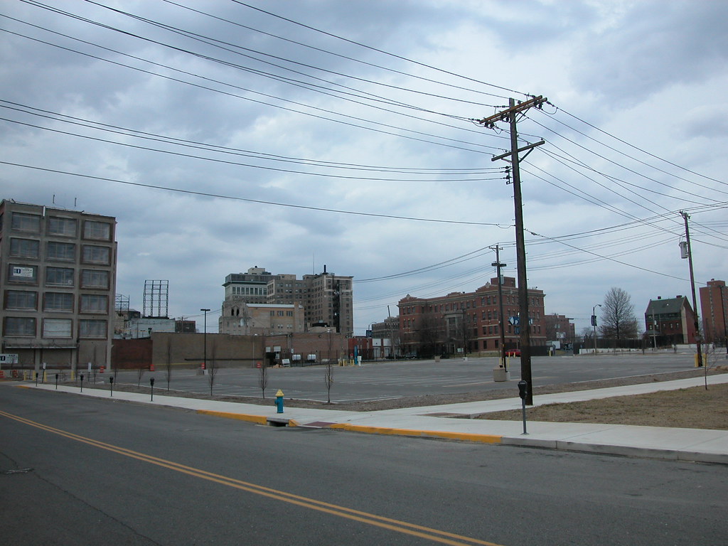
More "Urban" Is Not Always Better
 The old Raiffie Vending Company building at 3663 Forest Park Avenue may not look like much, especially since its owner has let it sit without windows for the past three years. However, the two-story modern brick building has great qualities. Built in 1948, the building has a streamline modernist style that, while not greatly articulated here, is quietly attractive. Since the windows were part of the building design, the stylistic character was more clear before removal. Built of steel and brick masonry, the building is solid. This is the type of construction that is infinitely adaptable and practical for almost any use imaginable.
 Of course, your mind might change when you see the new hotel that Sasak Corporation plans to build on the site of the modern warehouse. Five stories tall with wide street-level retail openings, this building adds more building density and urban connection to the site. Its masonry work is more interesting than that of the plain little box that now occupied the site, right? The hotel is a more urban building, you might think, and will add urban vitality to the site. Despite some flaws, like the 100-space garage in back being visible from the street through a pointless drive in front, this building makes the block more "urban" than the Raiffie building and thus constitutes an improvement.
Wrong.
Here is where the difference between rendering and reality comes into play. The developers are proposing to build this hotel at a cost of $90 per square feet, a price range below that of your average do-it-yourself Old North rehab. The masonry may look lovely in a tiny JPG, but it's not going to be brick in real life. The hotel will be clad in precast panels, spaced by those oh-so-obvious black seams.
Is the shift to "more urban" worth it if it means throwing away better construction for a cheaply-built building that meets all of the rote urbanist qualities? I say no emphatically. We can't keep throwing away buildings while we sit on an alarming amount of vacant land. There are many other sites in Midtown where a hotel could be built, and the old warehouse at 3663 Forest Park itself could be adapted if the developers wanted to try. But they'd have to spend more than $90 per square foot.
Wednesday, March 11, 2009
Dead Zone
 Over the weekend, I had the opportunity to spend some time at the site on Locust Street where the livery stable demolished by St. Louis University in 2007 once stood. The site would be located at the northwest corner of Locust and Josephine Baker Avenue, except that the university requested that Josephine Baker be removed.
The occasion was the filming of This Was the Future, a short documentary on the efforts to save the DeVille Motor Hotel (more on that film later). For the film, interview subjects were invited to select a site where a historic building once stood that is now an empty hole in a vibrant area. While it is hard to choose from some of the harsh empty lots we have in this city, I settled on what has to be one of the worst urban planning disasters in recent years.
 The two-story livery stable building was a bridge between the emergent renewal in the Locust Street Business District and the more established revitalization of Grand Center. Grand Center's motto is "the intersection of art and life," an acknowledgment of the power of crossroads. Here stood a building that was a crossroads, and now we have an asphalt chasm, and not even a literal crossroads since one of the two streets here is now gone.
Even as a warehouse, the livery stable exuded more life than the parking lot on a busy night. On a Saturday afternoon, not a single car was parked on the lot, and few were parked at nearby meters. Clearly, the lot is there for special events. However, trading the potential of daily urban activity in a rehabilitated building for the occasional overuse of a parking lot makes no sense in a central city location. Not at all.
The side effect of the livery stable debacle is the spatial segregation (through building density) of Grand Center from the emergent area on Locust and of Renaissance Place (through removal of Josephine Baker) from St. Louis University and Locust Street. Human-scale urban renewal has finally come to Midtown on Locust Street and at Renaissance Place, and a potential connection between those successes is lost, and replaced with a land use that not only divides but is totally alien to the surrounding urban fabric. We could have done so much better.
Tuesday, January 13, 2009
Cut Off From Hyde Park
 Eleventh Street continues north of Branch Street for two blocks, abruptly dead-ending where it meets the embankment of I-70. I-70 hems in the street and the pocket of residential Hyde Park that remains severed from the neighborhood. The city furthered this severance by officially drawing the Hyde Park boundary at I-70, which is certainly a barrier but nothing that defines any boundary of a neighborhood that has always started at the Mississippi River.
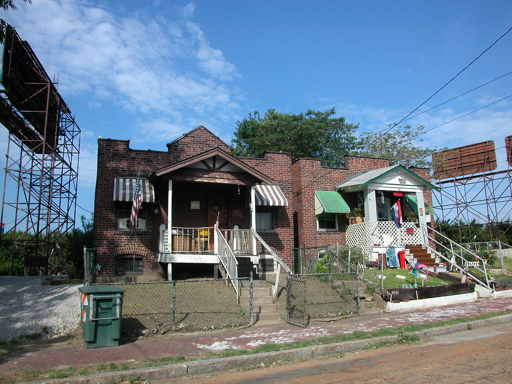
I love these two houses on the west side of Eleventh Street north of Branch. There are many small shaped-parapet bungalows in Hyde Park, built of pressed brick with wooden front porches. Houses like these line Agnes and Destrehan streets back in official Hyde Park. These homes date to the 1920s, when they went up en masse on undeveloped sites in the south end of the neighborhood. Few of those houses enjoy as dramatic a setting as these two now do. The highway in the back yard, giant billboards on each side -- the only comfort found in one of these houses is its well-kept neighbor. The brick sidewalk in front adds another reminder of the lost connection with the historic world of Hyde Park.
Wednesday, December 31, 2008
Talking About McRee Town

Yesterday afternoon St. Louis University doctoral student Jackie Jones presented her dissertation thesis, "Picturing a Neighborhood: McRee Town in Saint Louis, Missouri," to a crowd at the Royale, 3132 S. Kingshighway. The interesting venue for Jones' presentation and resulting discussion offered a relaxed setting for what remains a controversial topic: the wholesale clearance of six blocks of an urban neighborhood by the Garden District Commision and resulting replacement by new housing. Jones disavowed any stance on the clearance, instead focusing on how images were used to justify the clearance in the press -- and how other images contradict the story told by the Commission's carefully-selected images.
Here's Jones' own description of her presentation:
In 2003, the Garden District Commission demolished more than two hundred buildings on the eastern half of the McRee Town neighborhood in Saint Louis. The Commission, a private coalition headed by officials from the nearby Missouri Botanical Garden, demolished six blocks of historic brick homes and apartment buildings that housed primarily low-income renters and homeowners, relocated hundreds of residents, erected twenty-five acres of market-rate, single-family, suburban-style housing on the cleared land, and ceremoniously renamed the area Botanical Heights. This presentation explores how visual representations of McRee Town between 1998-2003 helped legitimize this urban renewal project and the dislocations it caused in the lives of McRee Town residents. It engages viewers with the photographs of burned-out, boarded-up, weed-infested buildings that populated newspaper reports and public relations documents during these five years, and juxtaposes them with photographs taken by Genevelyn Peters, a McRee Town resident prior to the neighborhood’s destruction. These images – of family, homelife, play, and community – complicate and challenge the dominant understanding of this neighborhood and its residents as criminal and atomized by presenting images that depict a vibrant neighborhood community.

The people present included someone involved in the decision to clear the six blocks, residents of Botanical Heights (the new housing development), the area's Neighborhood Stabilization Officer Luke Reven and others. While I had to leave before discussion was over, discussion touched on the damaging impact of I-44 construction in the early 1970s, the way in which similar images as those taken in McRee Town galvanized Lafayette Square and Soulard residents to pursue preservation instead of clearance, the deceptive nature of photographs and whether or not the term "suburban" applies to Botanical Heights.
On another note, if Royale proprietor Steven Fitzpatrick Smith is attempting to revive the tradition of the discussion salon, count me in!
Sunday, December 28, 2008
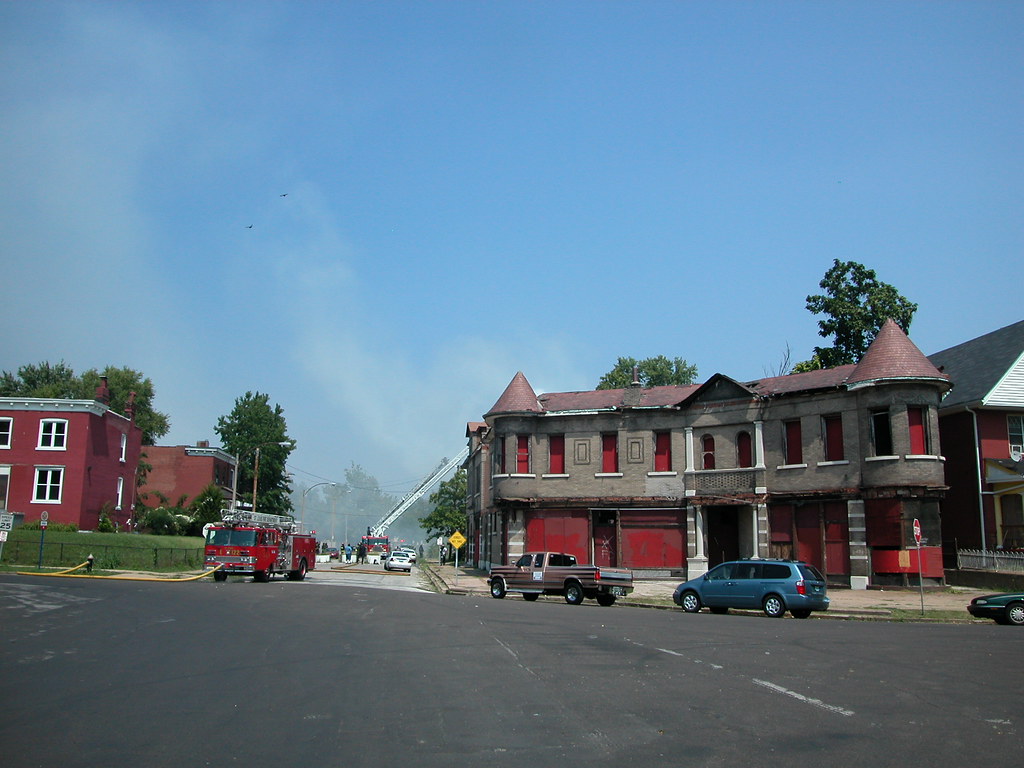
A Different Washington Avenue
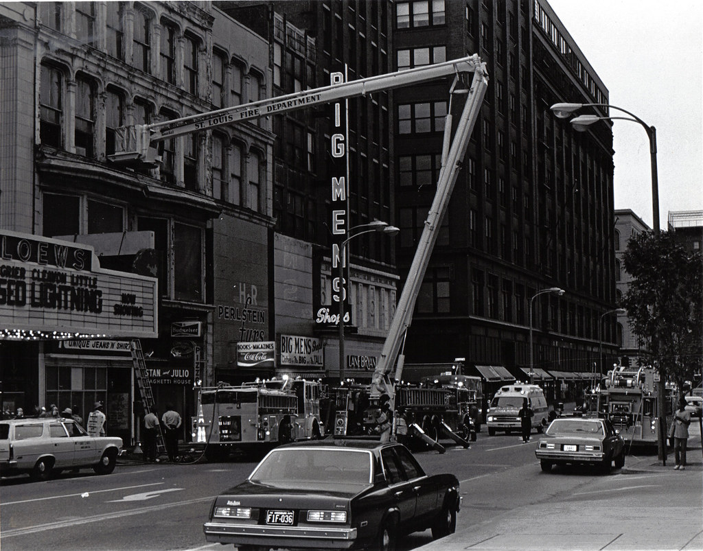 This photograph from the collection of Landmarks Association of St. Louis shows a section of Washington Avenue in 1978. Obviously, the photographer was intrigued by the Fire Department's activity, but ended up documenting more than just a one-alarm call. This view shows the north side of Washington from the mid-point of the 700 block east through the 500 block.
 From the left, one sees Loews Theatre still in business with its marquee advertising "Greased Lightning." Then there is Unique Jeans 'n Shirts, Stan and Julio's Spaghetti House, H.R. Perlstein Furs, Amitin's Books, the Big Men's Shop and Lane Bryant. On the next block east is the Stix, Baer and Fuller Department Store, later Dillard's, long before any skybridge marred its lovely commercial facade. Beyond the department store is the old May Company Building, now 555 Washington and then home of the Dollar Store.
This retail environment was dense with stores and small-scale buildings. The 700 block, with the exception of the theater, was occupied by narrow four-to-six-story buildings. These small buildings were the lifeblood of downtown retail in the 20th century, offering low rents and lower operating costs to owners. The buildings and the shops also imprinted streets like Washington, Locust, Olive and others with architectural variety and commercial abundance.
Alas, this photograph captures that downtown street life in end times. By the time this photograph was taken, city planners had decided to smother the retail environment here with the colossal failure that was St. Louis Centre. Opened in 1985, St. Louis Centre stands diagonally across from the Lane Bryant Store here. To build St. Louis Centre, two blocks of modestly-scaled historic downtown buildings -- all with ground-floor retail -- were leveled. St. Charles Street was closed. The two giant department stores, Stix and Famous-Barr, were joined to the mall rather than being separated by a diverse array of urban retail accessed on the sidewalks.
Retailers like Lane Bryant moved into St. Louis Centre and failed. Establishments like Stan and Julio's lingered until city planners again decided to stamp unitary order onto functional, if messy, urban life. In 1989, the 700 block of Washington was seized for construction of an addition to the convention center. Some retailers, like Amitin's, moved westward on Washington, but many closed their doors forever. The buildings fell. Today, the view captured in 1978 is depressing. Where delightful urban life thrived sits the giant convention center, with its sidewalks a pedestrian danger zone of taxi-dodging. The Stix building is empty, with a giant skybridge fused onto its facade that blocks sunlight and site lines.
Fortune may lead to rehabilitation of the Stix buidling, demolition of the skybridge and reconstruction of St. Louis Centre. However, the very urban architectural and commercial character of this stretch of Washington is lost.
Friday, November 7, 2008
Obama's House

Illinois Senator Barack Obama will soon be living in a famous historic home, and for that we are thankful, but his current residence is not unremarkable. Famously an owner of only one house, Obama resides in a spacious, historic home in Chicago's Kenwood neighborhood. The hipped-roof Colonial Revival home and adjacent lot -- regrettably made infamous during the campaign -- are found on a block familiar to millions of urban Americans.
While we all don't live in homes as large as Obama's or in neighborhoods as tony as Obama's pocket of Kenwood Kenwood, us city-dwellers can see ourselves in Obama more so than in any president in our lifetimes. Obama lives in a red brick house close to the sidewalk on a public street in a densely-populated neighborhood. Near the Obama family home is Washington Park, a magnificent but somewhat-untended city park. Washington Park mixes the aesthetics of Gilded Age aspiration with the contemporary reality of human life. Its paths are mostly full of people enjoying the beauty, but it has its share of vice and crime. West of the park is the CTA's Green Line, an elevated train line that carries thousands of Chicagoans to work, school church and nightlife.
To the south, Hyde Park and the University of Chicago place academic refinement smack-dab against neighborhoods where poverty is a real problem. North of Kenwood are neighborhoods whose fortunes are equally mixed. Barack Obama bought a wonderful home for his family, surrounded by the urban reality of his city. Obama's life is sheltered by necessity, but not by location. His home is in the middle of the diversity, wonder, agony and mystery of American urban life -- "real America" to many Americans. At times, cities seem to be as real as it gets.
Many American presidents -- including Richard Nixon and Bill Clinton -- have relocated to New York City at points in their career, but none in the last fifty years have come straight out of an urban neighborhood to the White House. These past fifty years have been terrible years for American cities. Seems like little coincidence that we have had presidents who come from that ether between the real life of the cities and the real life of the rural areas -- one place widely defamed by national politicians, the other mythologized in speech and neglected by policy.
Barack Obama has walked streets like ours and lived in a red brick house in the city. He has called an urban neighborhood in south Chicago home. At last, America has an urban president. At times, Obama will displease urban Americans -- after all, he is governing a nation with a suburban culture that is entrenched in national government. Yet Obama has actually lived urban America, and I can't help but think that will make a crucial difference in transportation policy, housing allocation, block grant funding and other areas.
Of course, Obama holds only the pen that signs the laws. The laws originate with our representatives. We have an urban president, and to make the most of that, urban America needs to step up and make its voice heard. Change doesn't end with Obama, it starts with us.
Tuesday, November 4, 2008
The Shady Oak Theater and the Big Box

Wreckers started taking down the shuttered one-screen Shady Oak Theater at 7630 Forsyth Boulevard. While not dazzling, the Colonial Revival building was a handsome building. Built in 1933 and designed by architects Frederick Dunn and Campbell Alden Scott, the theater was a reminder of the genteel character that Clayton once possessed. The theater's small scale was once part and parcel of the residential suburb's architectural character, but in the past twenty years was an antidote to the giantism and automobile storage worship that has befell Clayton.
On November 2, the St. Louis Post-Dispatch ran a story on the demolition that quoted Thomas Stern, president of Solon Gershman, the company that is wrecking the theater for surface parking. According to Stern, "[n]ow if you don't have 16 screens it doesn't make sense to run a movie theater. It has more value to us now for parking in the intermediate term."
In light of current economic circumstances, Stern's first statement is as baffling as it is illuminating. Even at the height of our recent credit glut, theater operators in the region's urban core had backed away from the super-sized multi-plex in favor of theaters of six screens or less. A one-screen move house is perfect for an urban area like downtown Clayton, where a residential population lies within an easy walk and land for a larger theater would be difficult to assemble.
With credit slow, I doubt that even the most exurban reaches of the St. Louis area will see a new 16-screen theater in the next few years. However, smaller movie houses with less overhead and closer to dense populations (especially wealthy populations like in Clayton) should do well. Stern's comment suggests an uncritical embrace of large scale development -- the attitude that has eroded Clayton's charm, killed off the Shady Oak and damaged our economy. While there are signs that attitude has lost much of its momentum, there is also the possibility that the economic crisis has only momentarily slowed down the pace of the big box culture. Let's hope that the big box is headed for the destruction that it has wrought on urban areas.
Tuesday, September 2, 2008
Fire in Fountain Park
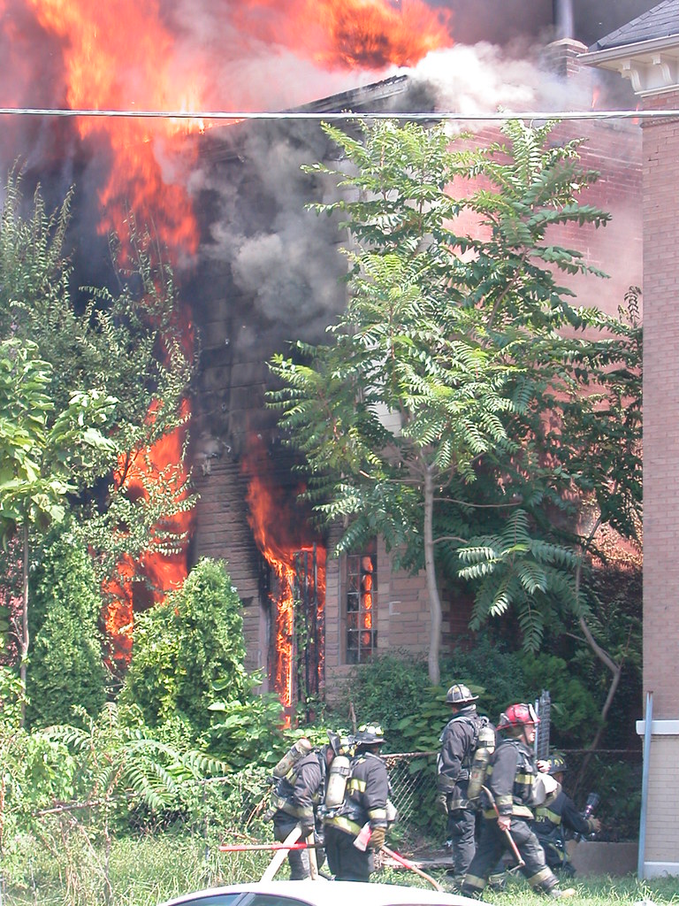 A sweltering, humid afternoon yesterday broke what had been a string of some of the most pleasant St. Louis summer days in recent years. In the Fountain Park neighborhood, the dog day brought more than just unpleasant weather. At around 12:40 p.m., a fire broke out at the abandoned home at 1124 Bayard Avenue. The blaze roared through a modest two-story home that has experiences fire twice before, according to a neighbor.
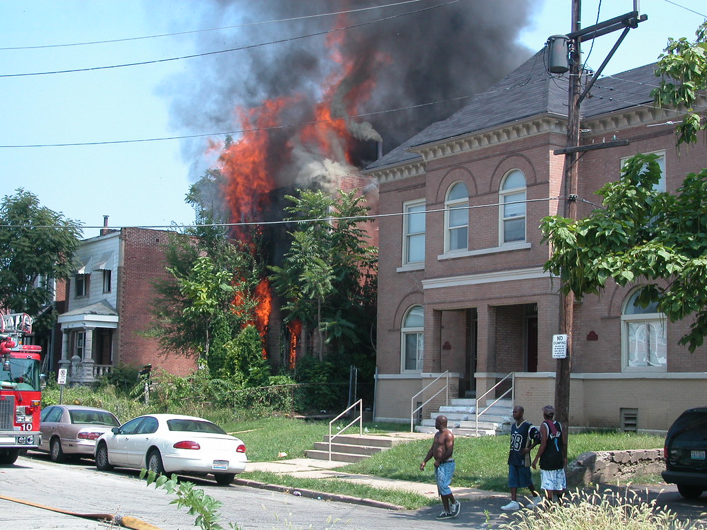 Neighbors who had been hanging out indoors in search of air conditioning came outside to watch a mid-day spectacle that is unfortunately a common occurrence in much of north St. Louis. Firefighters were quick to respond, and had the fire under control quickly. The firefighters surely earned the respect of the assembled crowd on Labor Day afternoon.
The house was not one of the stunning homes that line Fountain park proper, nor was it the nearby "castle" building. (The sight of dark smoke coming from near that structure made me shiver.) The brick home has acquired permastone on the first floor and flimsy siding above. Still, it had been a solid residence until going vacant two years ago. Its altered facade still made up part of a street scape wall that joins others to form the architectural context of life in Fountain Park. The house had a supporting role to the fancier buildings, but its loss will make the drama a little less full.
The neighborhood atmosphere yesterday was a far cry of the vision of John Lay, the Virginia farmer who platted 158 acres of his land just west of the city limits in 1857. Dubbing the subdivision "Aubert Place," Lay envisioned a fashionable middle-class enclave centered on an elegant park, like those he had seen in London. Early advertisements suggest that Aubert Place was a country retreat, and certainly the character of this area supported that assertion. Development was slow, even though half of the lots sold at auction in 1857. One reason for slow growth was the distance for public transit, which would not come for nearly another twenty years.
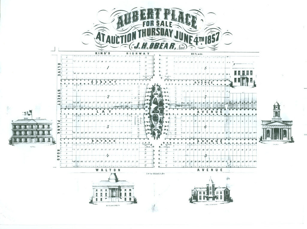 Most early homes here were frame, and only forty had been built by 1883. Still, annexation into the city in 1876 encouraged growth, as did the continued westward growth of the city. Streetcars came down Delmar to the south and Easton to the north, with a line also running straight down Euclid through the heart of the development. Development of the Central West End in the early 1890s coincided with the city's investment in the park in 1889. The city took the undeveloped central feature of Aubert Place and built amenities, including the fountain that would lead to the gradual name change of the neighborhood. Lay's charming suburb had been missing the elegance of a well-planned park. With lots reserved for single-family homes and a required twenty-foot set-back, Aubert Place was destined to be genteel. Building was rapid between 1892 and 1897, when two brothers named Davis built many homes. A second boom covers the years of 1903 through 1925, when unrestricted blocks around the original subdivision were developed with two-flats and other multi-family properties. Now known as Fountain Park, the neighborhood thrived with middle-class residents.
In the 1940s, Africa-Americans began piercing the housing restrictions in Fountain Park, at the time when many whites were leaving for more fashionable addresses west and north. A renewal took place, and the community remained strong for several decades until signs of decay crept in. To this day, there is amazing dichotomy in Fountain Park. Many blocks are very well-kept and retain their original beauty, while other blocks are marked by vacant lots, boarded buildings and vestiges of vice. Not surprising, the original Aubert Place is stronger than the outer tier of multi-family buildings. The posh Victorian middle-class suburb is now a problem-ridden 21st-century American urban neighborhood. That is to say, that for every day like yesterday, it has another good day. And for every beautiful home on Fountain, there's a house like 1124 Bayard.
More coverage:
Friday, August 22, 2008
A Fine Storefront Addition
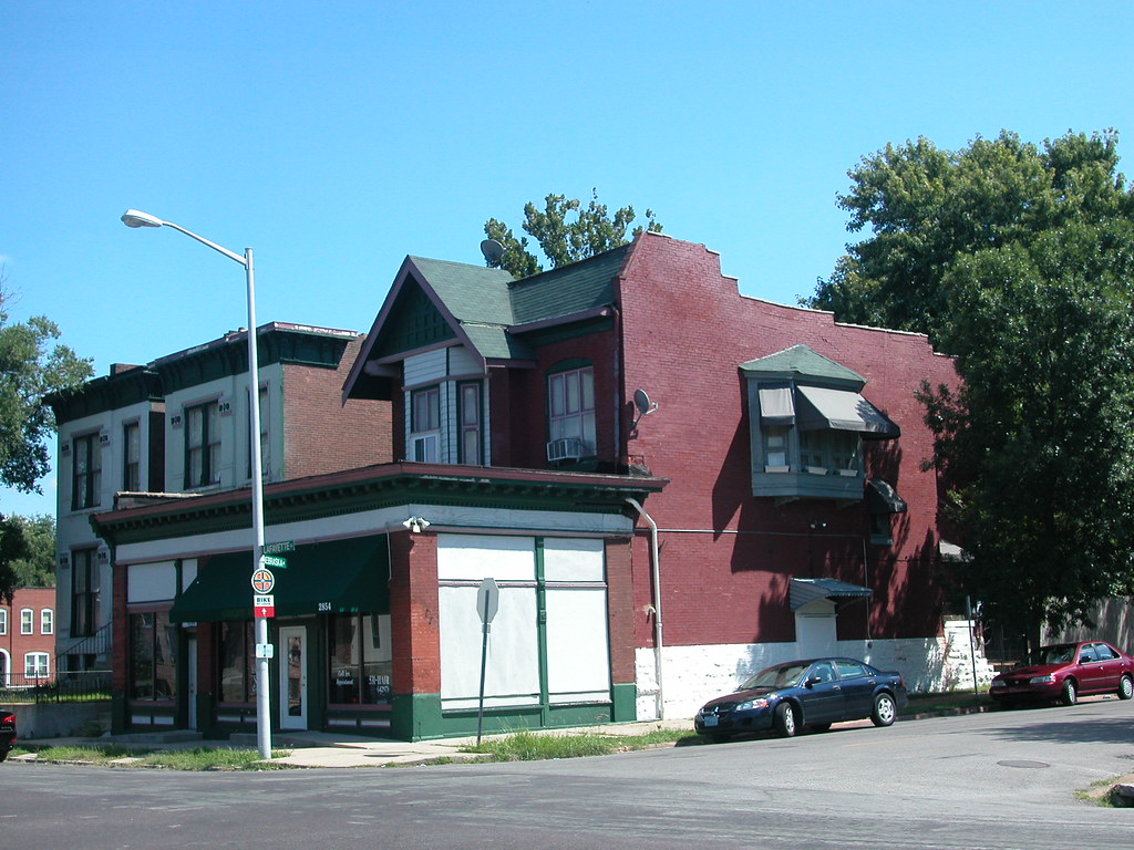 Storefront additions to residences were very common between 1920 and 1950 between on Lafayette Avenue between Jefferson and Compton in south city. I have written about two others (read them here and here) in this stretch, and neglected to point out a robust corner storefront addition at the southeast corner of Lafayette and Nebraska avenues. On the front of an eclectic Craftsman-inspired house with false mansard and front gable, we have the finest storefront addition on Lafayette. Actually, the addition houses two commercial spaces. Cast iron columns frame generously-glazed traditional storefront openings (which wrap the side), and an intact dentillated tin cornice with a second order of brackets provides a refined crown. Many of these additions bear the programmatic inelegance of their utility. Not this one.
Wednesday, July 30, 2008
A Side-Style Storefront Addition
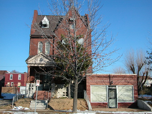
As I navigate the city, I am always on the lookout for storefront additions to historic homes. Regular readers will recall some recent posts of mine celebrating the sometimes-ungainly but always-intriguing vestiges of a city teeming with commercial life. The example above is located on the 2800 block of Lafayette Avenue just east of one that I chronicled seven months ago (Just Another Vacant Building?, December 21, 2007). That example was one of the prevalent types that stand in front of the parent house.
This one here, located at 2819 Lafayette Avenue, is of the gentler type. Built on the side lot of a stately single-family residence, the one-story flat-roofed addition creates more square feet of space on one level than the sort placed directly in front. I'm sure the builder's concern was with the economy of the structure, but the end result led to an addition that left alone the lovely front elevation of the Romanesque Revival house next door, built in 1893. That move proved fortuitous, as the front elevation retains original its limestone porch, granite details and wooden windows. The addition itself, probably built in the 1930s, is complementary without being dull. Spaced courses of pale brick, a continuous soldier course over the storefront opening and a framed frieze of angled brick offer simple but forceful masonry expression. We still have dozens of these additions left, and each one is a unique compromise between cost and ambition, change and history, old and new. These additions remind us that cities are creatures built for growth, and "historic" architecture is a tangle of buildings -- including historic buildings that block other, prettier historic buildings buildings.
Sunday, July 27, 2008
God and Man in St. Louis Place
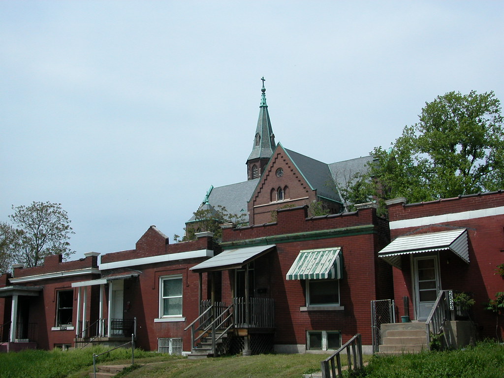
This striking urban view in St. Louis Place includes four one-story, shaped-parapet houses on Sullivan Avenue and the imposing Gothic roof line of St. Augustine's Church. This is the sort of view that doesn't happen overnight, and benefits from inherent architectural differences between forms, styles, heights and uses. The church, designed by noted ecclesiastical architect Louis Wessbecher, came first in 1896. Wessbecher also designed the majestic Bethlehem Lutheran Church on Salisbury Avenue in Hyde Park. The church served a largely working-class German parish, and its style is very influenced by North German Gothic architecture. Clearly, the church expresses the highest aspirations of the neighborhood at the turn of the last century. That aspiration has been recognized through both City Landmark and National Register of Historic Places designations.
The houses -- part of a longer row between Parnell and Lismore -- arrived in the first decade of the twentieth century. In contrast to the church, the houses were designed with great modesty by local builders. The one-story homes are mainly decorated with the shapes of the front parapets and simple tin cornices (some removed). Yet the buildings were sturdy and practical for their residents, offering a single-family home rather than a space in a tenement. The houses are not part of any historic district, locally or nationally. In this view, three of the four houses shown are owned by holding companies controlled by Paul J. McKee, Jr.
Here we have high style and vernacular, a spire reaching upward to the maker and the houses laid out low to the earth of the workaday world. While the contrast is strong, the image tells a very coherent story about the origin of this part of the neighborhood. The tale told about the future is less clear. The long-suppressed parish church has found new use as the home of a mission, but its repair needs seem extensive. The houses sit largely empty and in limbo as part of a development project with no clear parameters or timeline.
The narrative of our past that is embodied in these buildings built itself over time. All it takes is a moment for us to decide that their preservation is a worthy goal.
Monday, June 30, 2008
Healthy and Active Blogging
The staff of Trailnet's Healthy and Active Communities Initiative have been blogging away for the last two years. Not reading their work? You should be. The blog provides fresh and insightful information you don't get in many urban issues blogs -- writings about the history of food prices, developments in biodiesel, the problems with the abundance of corn in our diets and so forth. Just as autocentric urban planning is very unhealthy, so is an economic system that keeps nutritious foods off of the shelves of inner city groceries. Trailnet's staff keep pointing out how these two problems are related, and how the future of every urban area depends on more than just bricks and mortar.
Thursday, May 29, 2008
Urban Prairie in Downtown Evansville, Indiana
In the heart of Evansville, Indiana, just across the street from the former federal building, is this half-block of vacant earth. It's not a construction site. It's not a parking lot. It's just land with grass growing on it.
Monday, May 12, 2008
Tomorrow Night: Development Challenges & Rewards Discussion
DEVELOPMENT CHALLENGES AND REWARDS
Tuesday, May 13, 2008
7:00 p.m.
The Laurel Sales Office, 625 Washington Avenue
As part of Historic Preservation Week, ReVitalize St. Louis, the Rehabbers Club and Landmarks Association of St. Louis sponsor a panel including Jay Swoboda of EcoUrban Homes and Brady Capital and Stephen Acree of the the Regional Housing and Community Development Alliance, whose work has included many historic rehabilitation projects. Panelists will discuss their careers in St. Louis, the challenges they have faced and the current state of the city's real estate market. Question and answer session to follow -- bring your questions! Free.
UPDATE: Developer Will Liebermann, a developer who has done several projects on and around Cherokee Street, has joined the panel.
Sunday, April 13, 2008
A Lonely Stand
The future is always doubtful to that last historic house on a block in a neighborhood whose primary land use has changed. Neighborhoods just outside of the central business district of American cities that were residential walking neighborhoods typically lost their character in the twentieth century as commercial use crept outward. Large new buildings went up on main thoroughfares, followed by mixed use and apartment buildings on other streets. Old houses became rooming houses, offices and even small factories -- until their narrow lots were added to adjacent lots to make sites for larger buildings. Secondary streets often kept much of the old housing stock, but the main streets emerged from second wave development looking more like downtown than ever.
On some blocks, like the one shown above on North Avenue just west of Milwaukee in Chicago, one will find the houses that survived the development waves. Some of these houses stand alone, adjacent to parking lots. Their futures are doubtful, since they stand apart from the historic context that would make their defense likely should a developer want to take the house and the adjacent lot and build a new building. In Chicago, tear-downs like that seem to happen weekly. The new construction is often an insipid four or five story building with street level retail and condominiums above, rendered in a bland minimalist style or a gaudy postmodernist mess.
Other survivors are more fortunate, like this old Romanesque Revival house. When the building to the right went up in the 1910s, the developer didn't need, want or buy the house. When the building on the left went up, the same story. Neighbors came down, but not the erstwhile little house. The house slipped through both times. With such a small site, and the house being so close to the neighbors, one could guess that the house has escaped demolition. Then again, in urban real estate, nothing is ever certain.
There were years in recent memory when this stretch of North Avenue were devoid of much development interest, and then things changed rapidly. Even if the market is in downturn now, that won't last forever. Some locations hold inherent value that survives the market's cycles. Some buildings do too. Is this house one of those now, by virtue of its escape?
Saturday, April 12, 2008
The Soil Fails
Curtis Eller came up with a song title and phrase so haunting to those of us who live in north St. Louis. "After the Soil Fails" is really a song about a vivid dream inhabited by historical figures like William Tecumseh Sherman, but its references to the imagined deaths of New Orleans and Philadelphia invoke the condition of emptying sections of St. Louis.
"One of these days the soil is going to give out," warns Eller. While the causes of much of the loss of the built environment of north city is more economic, the landscapes left behind are devoid of any clues. To the innocent wanderer, perhaps it seems that the very land on which the city is built is dead. Just as bad soil kills crops, bad land could kill blocks or neighborhoods. The difference is that the infection of farm soil is real, while the infection of our city soil comes from within us, legitimate brown fields notwithstanding. City land is as good for city life as ever. Trouble is, city land's healthful properties come not from its physical content but from how it's labeled on maps and valued by builders. An ounce of soil from a lot in St. Louis Place could be as nutrient rich as any found in Clayton, but that has nothing to do with the value of the land it composes.
Hence, the best soil for farming in the region may be in places like the floodplains of St. Charles County, while the better soil for building could be the bedrock-pinned land of north city. We don't seem to mind this absurdity as continue to build out irresponsibly. If soil affected our settlement patterns as it does planted crops, our soil would have failed awhile ago. Maybe it still will.
Monday, March 10, 2008
Kaskaskia Remains

The villages of Dozaville (once Goshen) and Kaskaskia, Illinois remain as vestiges of settlement on Kaskasia Island. Dozaville is a complete ghost town, at least officially -- it has been legally dissolved for decades. Kaskaskia remains incorporated, although with less than a dozen residents in four households within its boundaries has no real need for civil government. Kaskaskia is one of those places that has achieved zero population growth according to the US Census -- a bizarre stasis for a town once of great importance.
Although part of Randolph County in Illinois, the island is west of the Mississippi and accessible only via a bridge from St., Mary's, Missouri. A shallow channel barely recognizable as a river separates St. Mary's from the island, suggesting that the land nearly is part of Missouri. On maps, the land seems fully engulfed by Missouri. Most maps don't even note the channel with water, but merely include a political boundary line. Kaskaskia seems an improbable location for Illinois's first state capital. Now remote, plagued by low land that constantly floods, and insular, Kaskaskia was once a vital part of early French settlement of the Mississippi River valley. The island was once an attached Illinois peninsula.
In 1673, Louis Joliet and Father Jacques Marquette claimed the Mississippi River valley in this area. In 1675, Marquette visited the site of Kaskaskia and established the mission of the Immaculate Conception. The mission became a church, and the settlement around the mission grew into a village with fur trading and farming as prevalent economic activities. In 1703, Kaskaskia was founded as the second village of European settlers in Illinois. By 1752, the population stood at a relatively robust number of 671 residents.
At the advent of the French and Indian War in 1756, French townspeople built Fort Kaskaskia on a hill east of the town, now across the Mississippi River. Residents destroyed the fort to prevent it from falling into British control when the British won. Many residents fled to Ste. Genevieve after the war. Later, the British built Fort Gage in Kaskaskia but lost the fort to Revolutionary General George Rogers Clark in 1778.
Kaskaskia became Illinois territorial capital in 1804. In 1818, the newly-created State of Illinois chose to retain Kaskaskia for the first state capital, although for only two years. The Emigrant's Guide of 1818 states that there were 150 houses standing in the village. Growth would not arrive, however, as the village quickly lost the capital to more centrally-located Vandalia. One notable event happened after the loss of the capital: the establishment of the convent and school for the female school Visitation Academy in 1833.
However, the biggest blows to the village's fortune came with terrible floods in 1844 and 1881. Located at a narrow spot between the Kaskaskia and Mississippi Rivers, the site was vulnerable to the Mississippi's eastward shift. Eventually, that river pushed over the narrow neck of the peninsula to create the present island. The first flood caused great population loss, and the second flood created the river channel that made the land around Kaskaskia into an island. During the period between the floods, Visitation Academy relocated to the city of St. Louis in 1844. After an 1893 flood, the town relocated to its present location.
In 1993, flood waters again submerged the island and caused residents to flee. Nowadays, the population of Kaskaskia is about 9 and the population of the island is about 93 people. Kaskaskia still retains its street grid, which carves out blocks punctuated by the few remaining buildings.
One of those remaining buildings is the Church of the Immaculate Conception, built in 1882 and moved to its current site in 1894 after the devastating 1893 flood. A church founded by Marquette now meets only on Saturday afternoons -- strangely diminished in human size but awesome in the length of its existence. The brick building has managed to survive several floods with its Gothic Revival architecture intact.

A long-time parishioner is profiled in the article found here.
A newer building is the home of the church's historic bell, gifted by the King of France in 1741 and known as the "Liberty Bell of the West" since the townspeople rang it on July 4, 1778 to celebrate liberation from British rule.
The old school house is interesting, although badly damaged by flooding and alterations to its fenestration. Boarded up, the brick building is missing much of its interior structure although it has gained a new roof since the 1993 flood. Reuse seems unlikely, although someone is performing enough continued maintenance to ensure survival of the old building.
A few frame and brick homes comprise the rest of Kaskaskia. The wide sight lines of the island ensure views of the church spire and school house framed by expanses of fields. Settlement has come full circle for Kaskaskia, but somehow it endures.
Monday, January 21, 2008
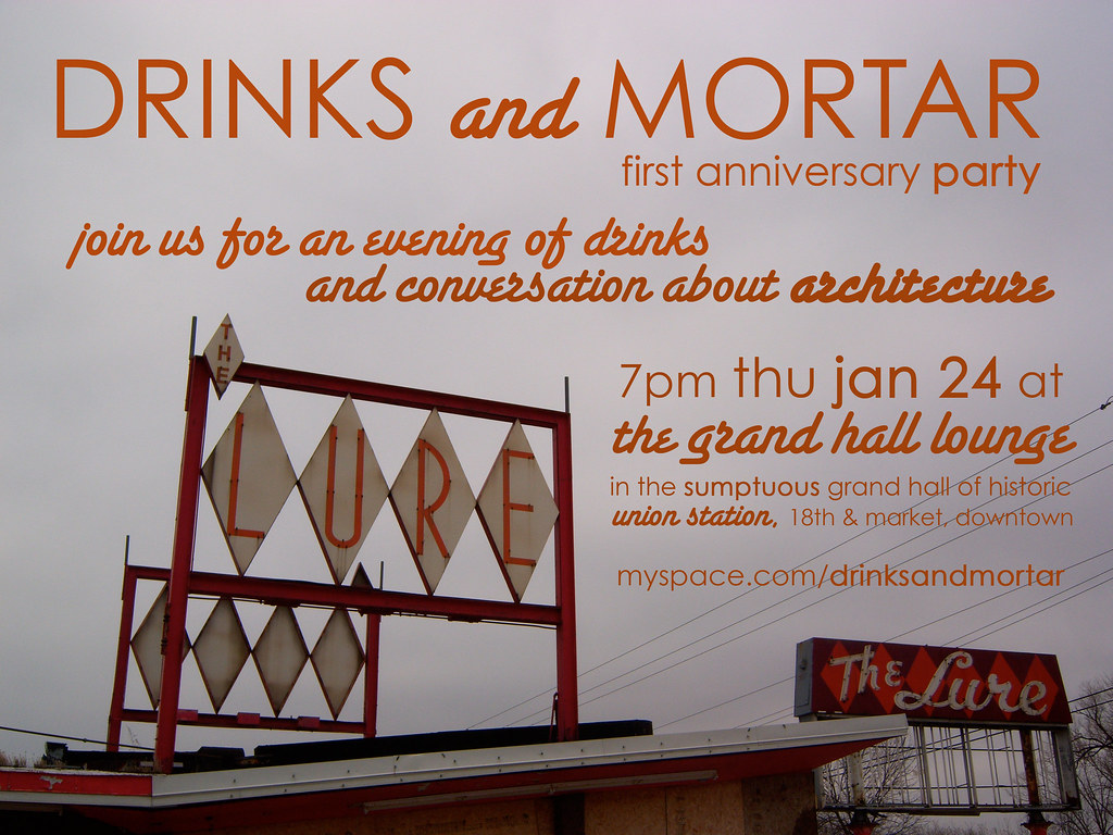
Drinks and Mortar's One Year Anniversary This Thursday
 Thursday night marks the first anniversary of Drinks and Mortar, the monthly gathering of people who like to talk about architecture. The gathering began after a group of people who were discussing simple and sustaining ways of connecting those interested in historic preservation, urbanism and architecture decide dto do something to get the ball rolling. For a long time there was no name to the event. One year later, there is a name, a Myspace website, a dedicated coordinator (Claire Nowak-Boyd) and a throng of regulars.
Hope to see you there!
When: Thursday, January 24 from 7:00 - 10:00 p.m.
Where: Grand Hall Lounge, Union Station, Market & 18th streets
More information: Drinks and Mortar
Monday, November 19, 2007
Foreclosure, Crime and Neighborhood Disintegration
According to an article on the CNN website entitled "Crime scene: foreclosure", Cleveland's historic Slavic Village neighborhood is in the nation's top ZIP code for foreclosures. An estimated 800 buildings sit vacant there. The neighborhood has out-of-control crime, correlated to the foreclosure rate. Houses get stripped within 72 hours of being vacated, and aren'ty worth enough money to justify repair. Police are inattentive, and the city can't afford to do much trash cleanup or demolition. People flee in droves, leaving those who remain in fear. Lenders continue to foreclose, with little concern about the effects.
This situation sounds a lot like conditions in north St. Louis in the 1960s, 1970s and 1980s. The article's eerie conclusion reads "as the number of empty lots and abandoned houses grows where houses and residents were once packed in a tight community, there are fewer and fewer neighbors to fight the battle."
(Thanks to Barbara Manzara for the link.)
Subscribe to:
Posts (Atom)